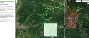
MB&G has assembled an application for viewing before-versus-after satellite imagery from the 2020 wildfire season, focusing on Western Oregon. Both conditions are derived from Sentinel 2 satellite imagery. Pre-fire conditions are from June-July 2020, post-fire conditions from September-October 2020. The image viewer can be accessed at: https://mbgfpeg.users.earthengine.app/view/orfireimpactsviewervx0aonsvxq1hqbox7yhmsu3fq6wy7hpttjyjunvsnjef
MB&G is proud to support the 2026 John Aho Golf Tournament by donating a pair of MB&G-branded pickleball paddles and balls for the tournament’s silent auction. Hosted by the Northwest Oregon Subsection of the Pacific-Northwest Section AWWA (PNWS-AWWA), the annual tournament raises funds for the John Aho Memorial Scholarship Fund and Water For People, helping support future water professionals while expanding access to safe water and sanitation in communities around the world.
READ MOREWhether you’re an investor, natural resource professional, conservation practitioner, landowner, researcher, or student, this course will provide practical insights into the financial, economic, and market forces shaping the future of natural resources.
READ MOREOne of our foresters was out working by the South Umpqua River near Days Creek last week and spotted an Osprey nest. After observing the nest for awhile a baby osprey popped out to get some sun and they were able to capture this photo.
READ MORE

